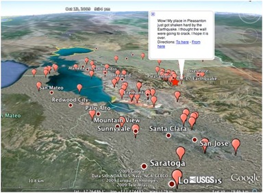
 This time it was personal. The earthquake hit three miles from my house. It was a minor one, magnitude 3.7, but I felt it very strongly, albeit very shortly, too. Just a sudden kick in the butt, nothing more. Perhaps that’s the difference between being right above the epicenter or feeling it remotely.
I jumped on Twitter, and I was among the first few to report the quake. Within seconds there were dozens, then hundreds of reports.
Not that it was a surprise, we’ve seen Twitter become the primary initial news source be it earthquakes, fires, military coups…etc. (For a while Google thought I was some earthquake expert simply because I pointed out Twitter was the first to report quakes in Japan and China.) But clearly, not all information on Twitter is reliable, as was the case of the fake LA earthquake video.
Wee need both speed and reliablity. The first comes from the crowd – nothing can beat having millions of “reporters” on the field, wherever, whenever significant events happen. But we typically do expect some form of verification, be it a traditional news agency, or in the case of earthquakes often USGS, the US Geological Survey. Until recently the information flow was one-way. But after yesterday’s quake I found an interesting link to the Google Maps mashup above. It’s created by @usgsted, the USGS Twitter Earthquake Detector. Here’s the explanation:
In this exploratory effort, the USGS is developing a system that gathers real-time, earthquake-related messages from the social networking site Twitter and applies place, time, and quantity data to provide geo-located earthquake detection within 60 seconds of an event’s origin time. This approach also provides a central directory of short first-impression narratives and, potentially, photos from people at the hazard’s location.
Social Internet technologies are providing the general public with anecdotal earthquake hazard information before scientific information has been published from authoritative sources. People local to an event are able to publish information via these technologies within seconds of their occurrence. In contrast, depending on the location of the earthquake, scientific alerts can take between 2 to 20 minutes. By adopting and embracing these new technologies, the USGS potentially can augment its earthquake response products and the delivery of hazard information.
To be fair, the USGS has not been entirely deaf even before: once you locate the relevant quake info (which is quite an achievement in itself) there is a Did You Feel It? link where if you are really persistent, you can provide feedback. The form is asking for a lot of data, takes a while to finish – enough to deter most. Which is why the fact the USGS is now embracing Twitter is a major milestone: it combines the speed of crowdsourced reporting with the verification / authority of experts.

(Cross-posted @ CloudAve )


Recent Comments